

Posts with tag 'bend oregon'
Subscribe and receive email notifications of new blog posts.
 RSS Feed
9
Bend Oregon Real Estate | January 2024 Trends
Bend Home Prices Leveling Off
The January 2024 Bend real estate market shows some stabilization. Although the average and median price per square foot are both up, the average and median sales price on sold homes comparing January 2024 to January 2023 show little movement. The issue most Bend home buyers are still dealing with is lack of inventory which provides few choices for people looking to purchase. Although mortgage interest rates have come down from the high rates pushing 8% seen last fall, they are still in the mid sixes which also impact the purchasing power for home buyers.
When the January 2024 sales for Bend single family homes on less than an acre are compared with those from January 2023, the following changes can be seen:
- Average sales price down 1.9% to $842,669*
- Median sales price up 1.5% to $699,950
- New listings down 14.7% to 99
- Homes for sale down 28.4% to 204
8
Bend Oregon Real Estate | 2023 Trends and 2024 Predictions
Bend Real Estate Sales Were Limited in 2024
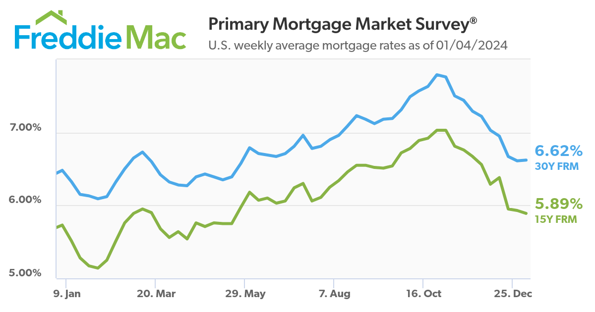
Probably the biggest challenge for Bend Home Sales in 2024 was mortgage interest rates. Mortgage rates started the year at 6.48% and ended the year at 6.62%. During the middle of the year, the mortgage rates rose to 7.79% which greatly limited the buying power for most Bend homebuyers who needed to finance in order to purchase. Home sales in Bend continued, but at a greatly reduced rate than experienced during Covid when mortgage rates under 4% were normal.
High mortgage rates also kept many Bend home sellers from listing. The thought for many was why sell and give up a great mortgage rate of less than 4% to exchange to one over 7% on a different home? Many Central Oregon real estate brokers discovered that many listings were limited to just those who had to sell for a job tra...
21
Mt Bachelor Village Real Estate Market Trends
Mt Bachelor Village is One of Bend's Oldest Resort Communities
Envisioned in the early 1970's by Brooks Resources as a resort community to house vacationers wishing to ski at nearby Bachelor Butte (now known as Mt. Bachelor), the successful condominium development of Mt Bachelor Village has grown beyond the 1/5th fractional ownership initially offered to now provide for fully owned units, townhomes and single-family homes with a variety of amenities and views. Its location, within Bend's city limits but just off the road to Mt. Bachelor and the high Cascade Lakes, Mt Bachelor Village has offered full time homes, investment opportunities, and vacation homes to owners and renters alike for well over forty years. It continues to be a venue for retreats, weddings, gatherings and conferences.
Due to its variety of offerings - everything from 1/5 interest condominiums to luxury single-family homes overlooking the Deschutes River, Mt Bachelor Village has a unique sales...
13
Bend Premier Real Estate | December 2023 Newsletter
What's in the December, 2023 Bend Premier Newsletter?
- Bend Home Sales Slow
- 5-Ingredient Peppermint Bark
- 7 Simple Steps to Prepare Your Home for Christmas
- Hike Paulina Falls at Newberry Crater Fall 2023
- 3 Reasons to Sell Your House Before the New Year
8
Tetherow Real Estate Market Trends
Tetherow is a Premier Luxury Golf Resort Community in Bend
The developer for Tetherow broke ground on the destination golf resort prior to the housing crisis of 2008. Initial lot sales were brisk, but once the great recession hit, sales dried up. The development sat with little activity until 2012 when lot sales, at a reduced price, started happening again. Over the past 11 years Tetherow has grown and become the destination resort initially envisioned with an active golf and social club, high end luxury homes and townhomes, a hotel, overnight rentals, three restaurants, and much more all adjacent to Bend's city limits on the road to Mt. Bachelor ski resort. It is truly one of Bend's success stories.
Market Trends for Tetherow Homes
Tetherow home prices have been among Bend's highest over the past three years. The Covid pandemic led to a mass migration to Bend and many wealthy buyers purchased in Tetherow pushing home prices even higher. However, over th...
Privacy Policy / DMCA Notice / ADA Accessibility